


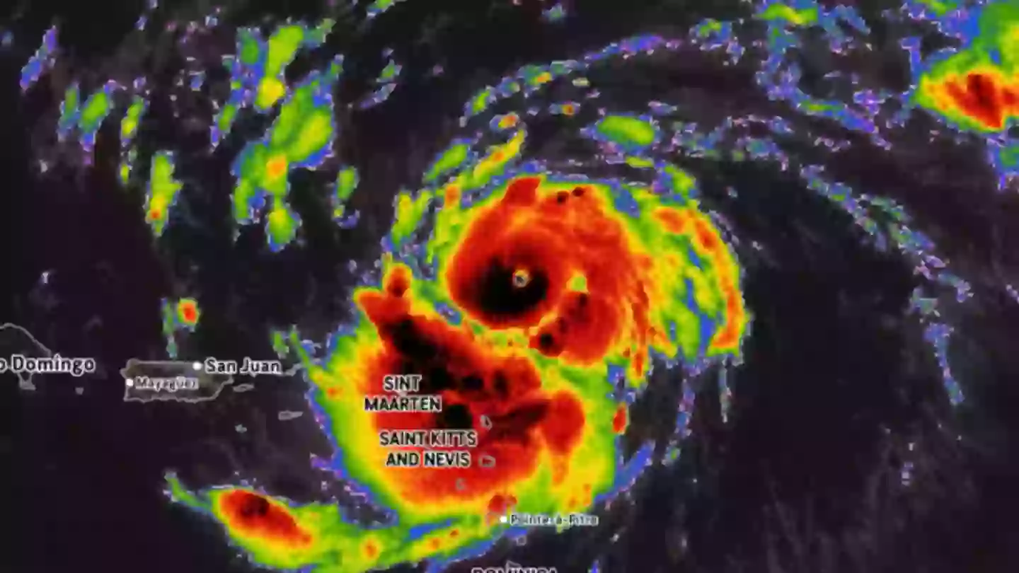
The Atlantic hurricane season has entered a dangerous phase as Hurricane Erin barrels through the ocean with recorded wind speeds of up to 160 miles per hour, prompting urgent warnings from forecasters about the potential for catastrophic damage.
The National Hurricane Center (NHC) confirmed that Erin, which first formed as a tropical system earlier this week, rapidly intensified from a Category 1 storm to a rare Category 5 hurricane in just 24 hours. Meteorologists note that only 43 storms in Atlantic history have ever reached Category 5 status, underscoring Erin’s severity.
What a Category 5 Storm Means
According to the NHC, a Category 5 hurricane is the highest level on the Saffir-Simpson scale, reserved for storms with sustained winds exceeding 157 miles per hour. Such storms are capable of causing catastrophic structural damage.
“Well-built framed homes can sustain severe damage with loss of most of the roof structure and/or some exterior walls,” the agency warns in its official advisory. “Most trees will be snapped or uprooted and power poles downed. Fallen trees and power poles will isolate residential areas. Power outages will last weeks to possibly months. Most of the area will be uninhabitable for weeks or months.”
This grim outlook is why meteorologists are monitoring Erin’s path with heightened urgency, particularly given its proximity to heavily populated areas along the U.S. East Coast.
Current Forecast and Trajectory
As of Saturday, August 16, the NHC issued a broad advisory covering the Bahamas, much of the eastern United States, and parts of Atlantic Canada. The storm is forecast to curve northward as it strengthens further over the weekend.
AccuWeather’s Lead Hurricane Expert Alex DaSilva provided more detail:
“Erin is forecast to slowly curve to the north as it continues to strengthen over the weekend. At this time, the storm is forecast to remain hundreds of miles off the East Coast,” DaSilva explained.
While landfall is not yet predicted, coastal areas from Florida to New England — and further into Atlantic Canada — are expected to experience hazardous conditions. “Beaches along the entire East Coast… will likely experience rough surf and dangerous rip currents as Erin tracks north and eventually northeast,” DaSilva added.
By Sunday morning, August 17, the storm briefly weakened to Category 3 status, though meteorologists caution that it could regain strength and return to Category 5 levels as it churns over warm Atlantic waters.
Areas of Greatest Concern
Although Erin is not currently forecast to strike the mainland directly, several regions remain especially vulnerable to secondary impacts. AccuWeather lists North Carolina’s Outer Banks, Long Island in New York, and Cape Cod in Massachusetts as particularly at risk due to their exposed geography.
These areas may experience extended periods of rough surf, coastal flooding, and erosion even if the hurricane stays offshore. Emergency management officials are already urging residents in these regions to remain vigilant, review preparedness plans, and stay tuned to official advisories.
A Season of Heightened Activity
Hurricane Erin is not an isolated event. The 2025 Atlantic hurricane season, which runs from June 1 to November 30, has been forecast to be more active than average. The National Oceanic and Atmospheric Administration (NOAA) has projected between 13 and 19 named storms this year, a number above the historical average.
The combination of warmer sea surface temperatures, atmospheric conditions conducive to storm formation, and reduced wind shear has created an environment primed for stronger and more frequent hurricanes.
Warnings From Authorities
The NHC emphasized that Erin’s strongest effects may be felt far beyond the eye of the storm. On Saturday, the agency posted on social media:
“#Erin is expected to produce life-threatening surf and rip currents along the beaches of the Bahamas, much of the east coast of the U.S., and Atlantic Canada next week.”
Such warnings highlight the wide radius of influence a Category 5 hurricane can have, with dangerous conditions extending hundreds of miles from the storm’s center.
Preparedness Remains Key
While officials stress that it is too early to predict with certainty whether Erin will make landfall, the unpredictability of hurricane tracks means residents along the eastern seaboard should not become complacent. Even without a direct strike, the combination of storm surge, rip currents, and heavy surf can pose lethal risks.
Authorities advise securing property, preparing emergency supplies, and heeding evacuation orders should they be issued. For coastal communities still recovering from past storms, the message is particularly urgent.
Looking Ahead
Hurricane Erin’s rapid escalation from a Category 1 to Category 5 system in such a short span has once again highlighted the volatility of modern storm systems. With the peak of the Atlantic hurricane season still to come in September, meteorologists are warning that Erin may be only one of several powerful storms to form this year.
For now, millions of people along the U.S. East Coast and Atlantic Canada are keeping a close watch, hoping that Erin’s projected curve keeps it offshore — while preparing for the possibility that the storm could change course.

James Jenkins is a celebrated Pulitzer Prize-winning author whose work has reshaped the way readers think about social justice and human rights in America. Raised in Atlanta, Georgia, James grew up in a community that instilled in him both resilience and a strong sense of responsibility toward others. After studying political science and creative writing at Howard University, he worked as a journalist covering civil rights issues before dedicating himself fully to fiction. His novels are known for their sharp, empathetic portraits of marginalized communities and for weaving personal stories with broader political realities. Jenkins’s breakout novel, Shadows of Freedom, won national acclaim for its unflinching look at systemic inequality, while his more recent works explore themes of identity, resilience, and the fight for dignity in the face of oppression. Beyond his novels, James is an active public speaker, lecturing at universities and participating in nonprofit initiatives that support literacy and community empowerment. He believes that storytelling is a way to preserve history and inspire change. When not writing, James enjoys jazz music, mentoring young writers, and traveling with his family to explore cultures and stories around the world.