


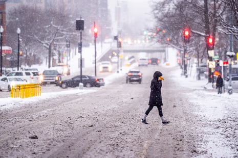
A massive surge of Arctic air is racing into the United States this week, unleashing what forecasters describe as some of the coldest temperatures anywhere on the planet. The plunging conditions are expected to grip the Midwest, Great Plains, and Northeast, placing tens of millions of Americans under harsh winter alerts and setting the stage for one of the strongest early-season cold blasts in recent memory.
Winter weather advisories, wind chill warnings, and cold-weather alerts stretched across 17 states on Wednesday, covering a vast belt from Montana, Idaho, and the Dakotas through the Upper Midwest and into Pennsylvania, New York, and much of New England. Meteorologists say the incoming cold front is behaving like a “wrecking ball,” sending temperatures crashing as much as 30–40 degrees below normal for early December and catching several regions off guard given the relatively mild start to the season.
At the core of this extreme pattern is a major polar vortex disruption — a phenomenon in which the swirling dome of cold air usually contained above the Arctic Circle becomes unstable. When this upper-level circulation weakens, fractures, or becomes displaced, massive pockets of brutally cold air spill southward into lower latitudes. This week’s event is a textbook example of that breakdown: a huge reservoir of frigid air, previously bottled up over western Canada, has broken free and is now plunging into the central United States with remarkable force and speed.
As this unstable mass pushes downward, it drags with it bitter winds, widespread snow, and potentially life-threatening wind chills. Forecasters warn that this is not merely a routine cold front but a sustained, multilayered Arctic invasion expected to evolve over several days, intensify through the weekend, and linger well into next week.
By the end of the week, parts of the Dakotas will feel like –45°F, while cities such as Chicago, Minneapolis, and Milwaukee could experience wind chills between –15°F and –25°F. Even areas much farther east — including New York City, Philadelphia, and Boston — are projected to struggle to climb above freezing during the day. In some communities across upstate New York and northern New England, daytime highs may remain locked in the teens, with overnight lows dipping near zero or below.
Forecast models show heavy snowfall developing across North Dakota, South Dakota, Minnesota, Wisconsin, Michigan, Pennsylvania, New York, Vermont, New Hampshire, and Maine. Some areas may receive between 6 and 12 inches, with locally higher totals in lake-enhancement zones and elevated terrain. Fast-moving storm systems riding along the Arctic boundary — including several quick-hitting Alberta clippers — are expected to intensify snowfall rates and create bursts of near-whiteout conditions.
Cities surrounding the Great Lakes — Chicago, Milwaukee, Detroit, Cleveland, Buffalo, and Erie — are preparing for a messy combination of snow, freezing rain, sleet, and glaze ice. With temperatures fluctuating rapidly around the freezing mark, these regions may see icy roadways, sudden slips into dangerous black ice, and disruptions to both ground and air travel. Snow squalls, known for their rapid onset and drastic reduction in visibility, may sweep through transportation corridors, particularly along Interstates 80, 90, and 94.
The severity of this Arctic intrusion becomes more evident as meteorologists begin to analyze the scale of the upper-air instability driving the event. One forecaster described the blast as a “textbook polar vortex mega-dump of western Canadian cold pool,” emphasizing that major metropolitan hubs such as Minneapolis, Chicago, and even St. Louis could experience temperatures 35–40 degrees below their long-term historical averages for the first week of December. In Canada, the cold is even more extreme: wind chills in parts of the Northwest Territories and Nunavut plunged to an almost unbelievable –80°F — temperatures that experts compared to a “cryogenic deep freeze” more commonly associated with interior Siberia.
These frigid conditions are the result of a complex interplay of atmospheric forces. Over the past several days, strong storms in the Pacific and shifting pressure systems across the Arctic displaced warm air upward into the stratosphere. This warming destabilized the polar vortex by disrupting its circulation and weakening the jet stream that typically contains the cold air. Once that containment broke down, the massive pool of Arctic air began to surge southward — first into Alberta and Saskatchewan, then into Montana and the Dakotas, and now sweeping broadly across the central and eastern United States.
As the frigid northern air collides with warm, moisture-laden air traveling north from the Gulf of Mexico, the resulting thermal clash sets the stage for widespread wintry precipitation. Meteorologists note that this collision of air masses enhances lift within storm systems, making snow bands heavier and increasing the likelihood of mixed precipitation types, including sleet, ice pellets, and freezing rain. These interactions will play a significant role in shaping the storm patterns expected to unfold through early next week.
The contrast is particularly sharp across the Ohio Valley, the Mid-Atlantic, and the interior Northeast, where temperatures may vary by as much as 25 degrees within a span of only 50–100 miles. Residents in these transition zones should be prepared for highly variable conditions, including rapid temperature drops and unexpected changes from rain to sleet or heavy snow.
Climatologists warn that some of the coldest temperatures on Earth will blanket the central and eastern United States into early next week. This includes the potential for new daily record lows across several states in the Plains and Midwest. In addition, several cities may register record-breaking cold maximum temperatures — meaning their daytime highs could be the lowest ever recorded for this date.
With conditions evolving quickly and multiple systems moving along the Arctic boundary, forecasters are urging Americans in affected regions to take precautions. These include preparing vehicles for cold-weather operation, checking heating systems, keeping extra blankets and winter gear in cars, and limiting time outdoors during periods of intense wind chill. Hypothermia and frostbite risks increase significantly when wind chills drop below –30°F, and many regions will fall well into that danger zone by the weekend.
Emergency management officials are particularly concerned about vulnerable populations, including the elderly, the homeless, and those living in poorly insulated housing. Local governments across several states are opening warming shelters and urging residents to check on neighbors who may lack adequate heating.
Air travel disruptions are also likely, especially in major hubs such as Chicago O’Hare, Minneapolis–St. Paul, Detroit Metropolitan, and Boston Logan. With multiple fast-moving systems expected, airports could experience delays from de-icing operations, visibility issues, and runway complications caused by freezing rain or rapid snowfall rates. Road travel across northern states is also expected to become hazardous, with transportation departments warning drivers to expect slick surfaces, sudden squalls, and periods of limited visibility.
The deep freeze may also pose risks to infrastructure, including the possibility of frozen pipes, power line stress, and increased energy demand as heating systems run at maximum capacity. Utility companies across the Midwest and Northeast are preparing for peak-season load levels and reminding customers to conserve energy where possible without endangering household safety.
More waves of bitter cold and additional snowfall are expected as December continues, marking what could be one of the most severe early-winter cold outbreaks in recent years. Long-range models suggest that the jet stream will remain displaced for several more weeks, providing a pathway for additional Arctic air masses to move southward. While temperatures may moderate briefly between systems, the overall pattern remains conducive to repeated cold blasts into the second half of the month.
For now, experts advise that the nation brace for a prolonged period of intense cold, significant snowfall, and persistent winter hazards. With millions under winter alerts and more storms on the way, the first half of December is shaping up to be a defining chapter in this year’s winter season — one marked by sharp temperature anomalies, powerful atmospheric disruptions, and an Arctic outbreak that will be remembered long after the snow melts.

Emily Johnson is a critically acclaimed essayist and novelist known for her thought-provoking works centered on feminism, women’s rights, and modern relationships. Born and raised in Portland, Oregon, Emily grew up with a deep love of books, often spending her afternoons at her local library. She went on to study literature and gender studies at UCLA, where she became deeply involved in activism and began publishing essays in campus journals. Her debut essay collection, Voices Unbound, struck a chord with readers nationwide for its fearless exploration of gender dynamics, identity, and the challenges faced by women in contemporary society. Emily later transitioned into fiction, writing novels that balance compelling storytelling with social commentary. Her protagonists are often strong, multidimensional women navigating love, ambition, and the struggles of everyday life, making her a favorite among readers who crave authentic, relatable narratives. Critics praise her ability to merge personal intimacy with universal themes. Off the page, Emily is an advocate for women in publishing, leading workshops that encourage young female writers to embrace their voices. She lives in Seattle with her partner and two rescue cats, where she continues to write, teach, and inspire a new generation of storytellers.